Land Resource Management
Role
Land resource management is the process of managing the use and development (in both suburban and rural settings) of land resources in a sustainable way. Land resources are used for a variety of purposes which interact and may compete with one another, so it is desirable to plan and manage all uses in an integrated manner. The County owns over 8,000 acres that are either wetland mitigation sites or other green spaces like parks that need to be maintained for the public.
Components
Some components of active land resource management in St. Johns County include timber management, invasive species treatment, native plantings and prescribed fire on County-owned conservation and park properties throughout the County. Also included are maintenance of properties in compliance with permits and grants as well as collaborative efforts with other land resource management entities such as the St. Johns River Water Management District, Florida Fish and Wildlife Conservation Commission, United States Army Corps of Engineers and the Florida Forest Service.
Some habitat restoration activities managed by County staff include:
- Timber Management
- Invasive Plant Treatment
- Native Plant Planting
- Prescribed Fire
Overview
Habitat loss is the leading cause of native species and ecosystem decline. Conservation of viable habitat and restoration of damaged ones can reverse this trend. Existing laws are in place for protection and preservation of many natural habitats and species, however restoration and ongoing management is needed on public lands to protect the critical services the environment provides. Restoration is defined as the process of returning a degraded habitat to a self-sustaining condition that resembles as closely as possible its state before disturbance. The practice of restoration includes activities such as removal of non-native species, planting back native species, reforestation and wetland creation, prescribed burning and restoration of historic stormwater flow across the land.
Overview
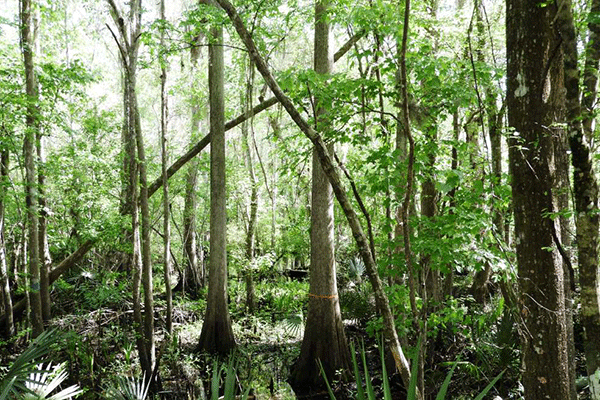
Located along the southeastern coastal plan, St. Johns County has an array of existing natural wetland features. Some wetlands are created over time as low areas between dune systems or other low features relative to other areas of the land. Federal and State laws require any new roadway, commercial, residential or industrial development projects to identify wetland areas within the property and show which areas will be preserved or impacted as part of a required development permit. As a part of the design of a proposed development, the unavoidable wetland impact areas must be evaluated to make sure remaining wetland areas can still function or the impacts are offset in other areas. A wetland enhancement, restoration, creation or preservation project that serves to offset unavoidable wetland impacts is known as mitigation. Mitigation activities may be either onsite or in special offsite mitigation sites where a developer can purchase credits from mitigation “banks.” Mitigation must also take place within the same regulatory drainage basin as the impacts.
Most wetland impacts that result from road projects which do not allow for on-site mitigation. Mitigation banks that can be used for County projects are costly. When St. Johns County has a new project, including new roads, it must provide the mitigation for any wetland impacts just like any other development.
ROMAs (Regional Offsite Mitigation Areas)
St. Johns County has proactively established what are called Regional Off-site mitigation areas (ROMAs) for impacts associated with County projects. ROMAs are large tracts of land that are enhanced by the County, are recorded as conservation easements and provide high-quality habitat for wildlife and passive recreation opportunities (hiking, birding, etc.) for its citizens. The ROMAs result in significant wetland mitigation cost savings and also provide green space for County residents. The County’s ROMAs and many other smaller acreage conservation areas that have been recorded under conservation easements for mitigation credit have saved the County several million dollars in private wetland mitigation bank credit purchases and added thousands of acres to the County’s conservation lands portfolio. Timber thinning sales that the County is required to perform in the enhancement of ROMA properties has provided hundreds of thousands of dollars in revenue since the early 2000s. The County is also able to use funding out of the development community-funded Tree Bank Fund for required land management activities, contributing to further savings to County residents.
ROMA Projects
Turnbull Creek
Acquired in the early 2000s, this 760-acre parcel is located off SR 16 just south of South Francis Road. It is combined with another 400 acre conservation easement which preserves over 1,000 acres near the headwaters of Six Mile Creek.
The property is being restored and protected as a result of mitigation activities. Water flow has been restored by removing forestry roads and filling old ditches associated with a former timber farm on the property. The forest has been thinned back out to more natural densities and prescribed fire has been introduced to the site to mimic natural conditions. A 10-acre wetland creation area has also been developed and is thriving with native aquatic plant species which that is used heavily by migratory and native water fowl.
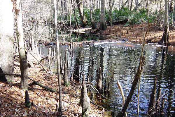
Deep Creek
Acquired in the late 2000s, the 235 acre ROMA is located in the Hastings area and is comprised of 3 separate tracts of land. Two of the tracts are in preservation and various states of restoration and one tract includes a large pond and created wetland area that receives and treats water runoff from the local vicinity before discharging to Deep Creek, which flows through the Hastings area out to the St. Johns River.
Moses Creek
Acquired in the late 2000s, the 450 acre ROMA is located near the intersection of State Road 206 and US 1 South and includes two separate properties that are currently being restored and preserved.
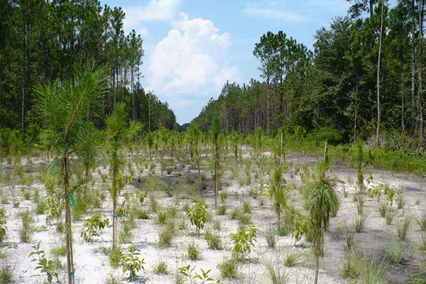
McCullough Creek
This is a 1,400 acre property located on County Road 13 South, just north of the County Road 305 intersection and several miles north of State Road 207 in the Hastings area. The property represents the County’s most recent acquisition which occurred in 2018 and the County is currently in the process of permitting a ROMA on the site with State and Federal agencies. A majority of the property is currently in silvicultural pine rows and once permits for the ROMA are received, it will be thinned out slowly over the next few years to restore the site back to natural conditions. Additionally, any invasive plants will be treated and prescribed burning of the pine flatwoods communities will begin once the timber rows have been removed. As the property has parking areas located off County Road 13, County residents will be able to visit the property for hiking, biking and wildlife viewing. Sport hunting will also be allowed on portions of the property by sanctioned groups periodically throughout the year.
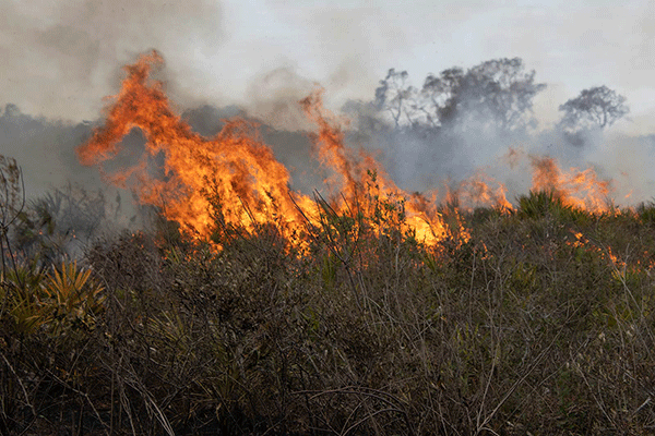
Fire in Florida
Fire is one of the most versatile and cost effective land management tools within Florida. Forests in the southeast U.S. owe their existence to a long history of periodic fires. Forests in Florida have existed for at least 12,000 years and thousands of fires occurred naturally by lightning strikes. Fires, like many natural events, are cyclic and governed by conditions such as climate and existing vegetation. The repeatability of the cycle varies depending on habitat.
A Natural Cycle
Before 1900, fire-susceptible areas burned naturally every three to ten years. However, even in areas less likely to burn, the cycle still repeats every ten to 100 years in Florida. Fire is important to our landscape because it breaks down complex organic molecules to smaller ones – the same thing that occurs when we digest food. When a fire changes a log to ash, nutrients bound by chemical compounds are released and changed to a form where they can be more readily utilized.
The Impact of Development
Thousands of years of natural fires resulted in a dynamic balance between various habitats and the wildlife that live here. Historically, fires would burn across a landscape unhindered by highways and housing communities. Since the early 1900s, humans have fragmented our landscape and fires cannot burn in a natural pattern. Thus, when a fire does occur, it can be catastrophic due to mass build-up of understory native plants, like palmetto and gallberry. How, then, can the powerful force of fire be used in a way that cooperates, not conflicts, with nature?
Restoring the Balance
Prescribed burning is one way in which land managers have attempted to simulate historic fire patterns. Native Americans knew the benefits of fire and had been utilizing prescribed burning for centuries to control insects, create space for crops and improve wildlife and grazing habitat. Modern land managers use fire to reduce hazardous fuel buildup, thus providing increased protection to people, their homes and the forest. Other uses include disease control in young pines, habitat improvement for wildlife, range management, preservation of endangered plant and animal species and the maintenance of fire dependent ecosystems. Depending on weather and site conditions, The Florida Forest Service reports hundreds of thousands to millions of acres treated with prescribed burns each year.
County Land
The County has three parcels in which periodic prescribed fires are performed by a contracted and authorized prescribed burn contractor in compliance with State and Federal agreements and land management plans. These include the Turnbull Creek, Moses Creek and McCullough Creek Regional Offsite Mitigation Areas.